Rainwater Harvesting: The Key to Mitigating Flooding and Protecting Soil Health

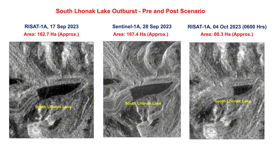
In our previous blog, we delved into the swift cascading of water from upstream regions, unfortunately resulting in a rapid departure without replenishing groundwater aquifers.

Consequently, this water accumulates downstream, particularly in plains and farmlands, for an extended and undesirable duration. Besides the visible surface flow, there is an ongoing, invisible subsurface movement beneath the Earth’s surface.

When water falls on hills, it can infiltrate the ground, becoming subsurface water. Excess water accumulates in the subsurface if the soil is saturated or the terrain is poorly drained. It then flows downhill, potentially causing flooding through a process called emergence.

This type of flooding disrupts the delicate ecological balance in a given area, affecting the intricate relationship between soil and plants. Plants require a specific depth of aerated soil for optimal growth, with oxygen playing a vital role.

The Impact of Flooding on Soil

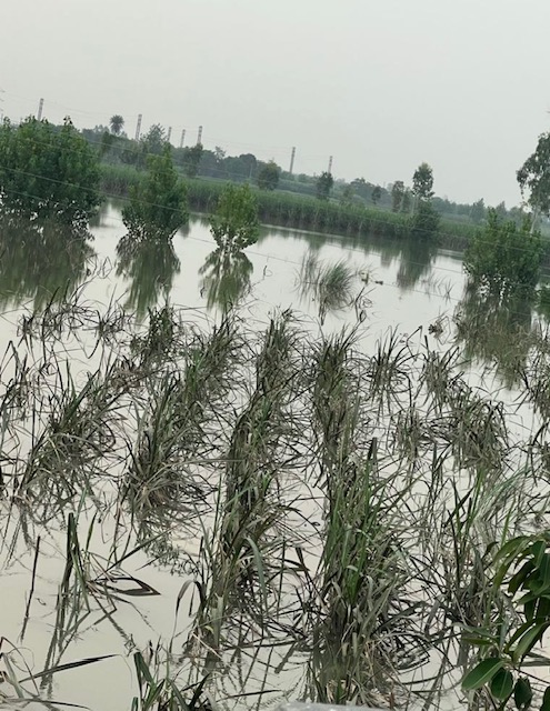
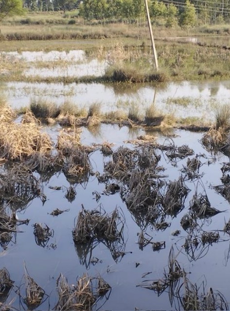
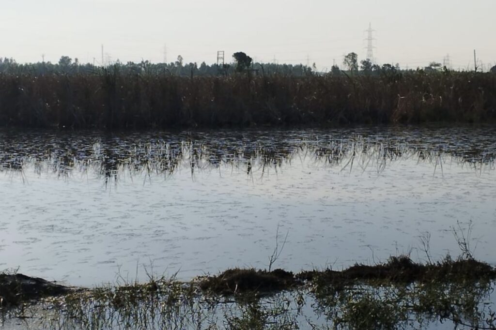
The aftermath of such flooding leads to waterlogged soil, nearing saturation and impeding aeration, creating anaerobic conditions. This depletion of oxygen in the root zone adversely impacts microorganisms crucial for supporting plant growth, restricting overall plant growth.

Water logging reduces soil temperature and increases dampness, disrupting biological activities within the soil. It also vastly affects operations related to soil enrichment and development, affecting irrigated agricultural lands.

Water logging often coincides with soil salinity, impeding the leaching of salts brought in by irrigation water. This exacerbates adverse effects, especially when salts from lower soil layers are transported upward by capillary action.

Rise in soil salinity disrupts nutrient absorption by plant roots, damaging plantations and altering the physical characteristics of the soil. The soil becomes less permeable to water and more prone to runoff, negatively impacting neighboring lands and vegetation. Even fodder grown in such soil may pose health risks to livestock.

Based on our three decades of experience, we have learned that flooding exerts a prolonged detrimental influence on soil. While immediate effects may not be readily apparent, long-term consequences involve a gradual degradation of soil quality, diminishing its water absorption capacity.

In reality, the water wreaks havoc both upstream and downstream, presenting a clear situation before us.

Case Study: Trial Bore in Flood-Prone Haryana

At SILVERON, we recognize the tangible and intangible losses incurred due to flooding in India, seeing it as an immeasurable national setback. We recognize the challenges of rapid infiltration posed by limited soil permeability or impermeable layers. We have proposed a strategic solution involving the implementation of drilling recharge shafts.

Our well-established design not only facilitates surface water infiltration but also intercepts subsurface flow, contributing to the replenishment of groundwater levels. The unlined bore design of our recharge shaft enhances its effectiveness in checking subsurface water.

Once water finds an easy path through the shaft, it establishes a regular route, attracting more water towards it. By enhancing the rate at which water permeates the ground, our solution holds the potential to significantly mitigate the impact of flooding.

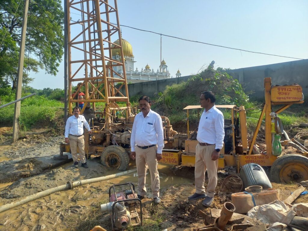
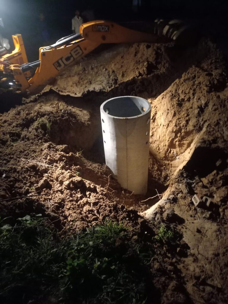
We conducted a trial bore to test our shaft design in challenging flood management conditions, despite our confidence and experience.

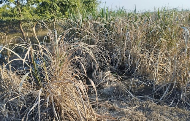
As part of our social responsibility, we installed a Trial Recharge Shaft, at our own cost, in the flood-prone plains of Haryana. These plains experience annual inundation during monsoon as they sit below the mountains of Himachal Pradesh.

Our Endeavor

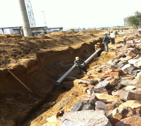
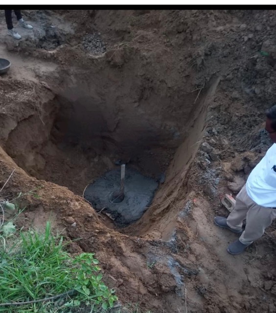
  1. We drilled the trial bore to appropriate depth to take advantage of soil strata having good absorption capacity and developed the recharge shaft following our standard basic design.
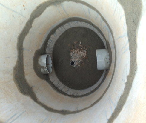
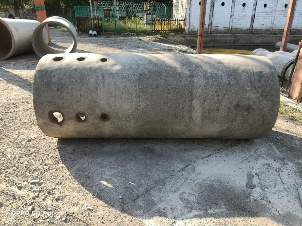
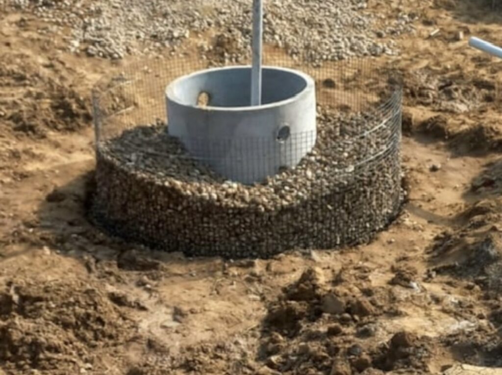
  • We deployed custom-designed Hume pipes, with a special 3 feet diameter and 8 feet length. These pipes featured holes of varying diameters (2, 4, and 6 inches) to facilitate water entry into the Recharge Shaft. Positioned at an 8 ft. length, 5 ft. of the pipe submerged into the ground, with 2-inch diameter holes positioned about 6 inches above the ground. Hole sizes are arranged in increasing order, considering the diminishing quantity of suspended silt as the water level rises.
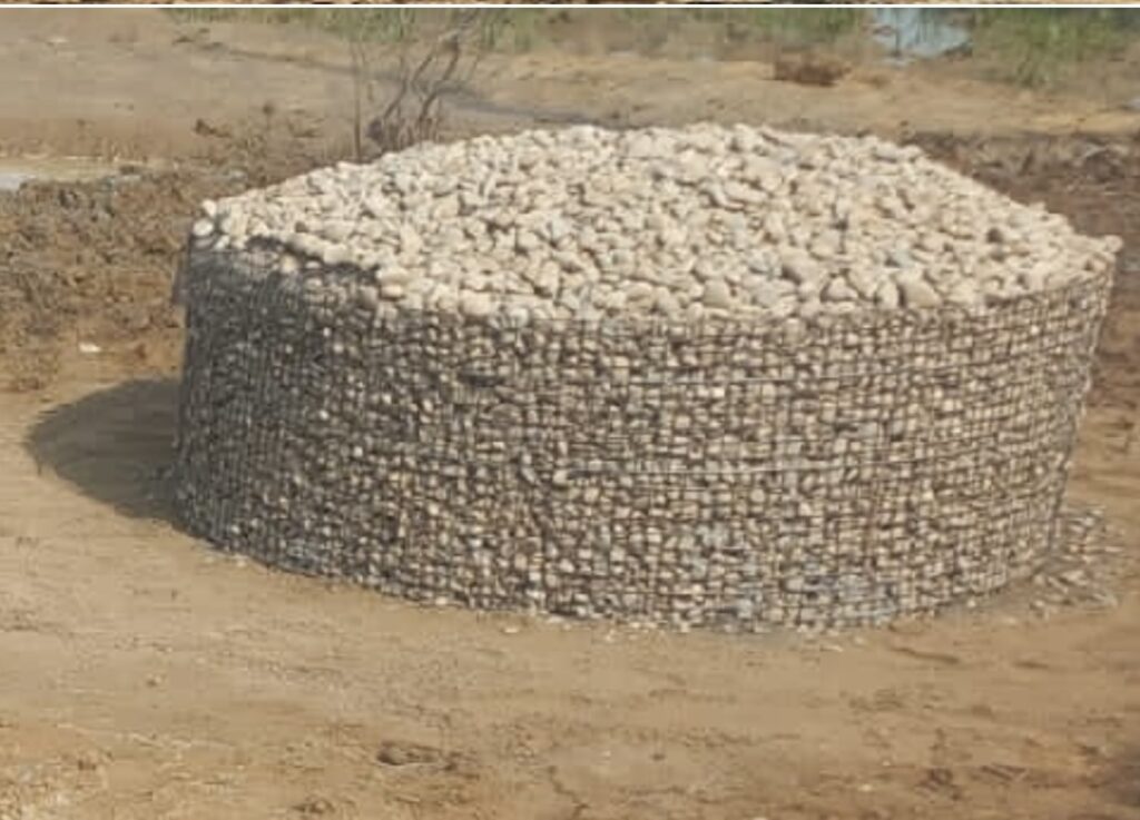
  • A wire mesh barricade, standing at a height of 3 ft., was grouted around the Hume pipe, 3 feet away in all directions. We fill the space within the Hume pipe, between the pipe and the wire fencing with aggregate. This system prevents entry of suspended leaves, paper, polythene, and captures a portion of the suspended silt by reducing velocity. We then cover the top of the structure with wire mesh and aggregate.

These structures effectively mitigate the impact of running or collected rainwater, preventing serious damage to field soil or crops.

It’s noteworthy that each recharge shaft maintains a consistent intake speed, with observed likely intake flow around 200 cubic meters per day.

               Triumph is attainable solely through proactive endeavors.  

Preparing for the Worst: Mountain Lakes and Natural Catastrophes

Parts of Asia and South America have mountain regions prone to a high risk of flooding due to mountain lakes breaches and bursts.

In India, the Himalayas are home to a large number of glaciers. States like Jammu & Kashmir, Ladakh, Uttarakhand, Sikkim, Arunachal Pradesh, Assam and Himachal Pradesh are vulnerable to this phenomenon because of a large number of mountain lakes.

Mountain lakes often have base and walls made of debris and loose rocks. As the climate warms, new lakes are forming, and the dimensions of existing lakes are increasing in size, causing them to hold even larger quantities of water.

Over time, snow accumulated in mountainous regions compressed into glacial ice.  As temperatures rise, glaciers melt and carving large arena shaped depressions in the landscape. Retreating glaciers leave behind rocks and debris creating a wall or a natural dam to block the flow of water.

Various geological processes, such as tectonic activity, create natural depressions in mountains when movements in the Earth’s crust occur. Water flows from snow-melt, seasonal rainfall or cloud bursts replenish glacial lakes or mountain lakes  in elevated regions. 

Increasing changes in climate patterns, including more intense and frequent storms, altered precipitation patterns, and temperature variations are already influencing the hydrological cycle globally. The unique topography of mountains enhances the likelihood of notable phenomenon which leads to massive flash floods.

The dynamic mountain landscape, combined with natural and human-induced factors, contributes to the complexity of water flow patterns. These complex factors lead to increased volume and velocity of water flow from mountains to downstream plains. This causes flooding, potential damage to buildings and crops downstream.

Here is a clip from recordings done by our team from such locations.

Major Causes

  • Cloud Bursts: In mountainous regions, the terrain’s elevation forces moisture laden air to keep rising. As the air rises it cools, reaches its dew point and rapid condensation occurs. This process is known as orographic lifting. The primary cause of cloud bursts is the rapid condensation of moisture in the atmosphere, leading to sudden and very heavy rainfall in a short period over a localized area. This intense rainfall over a short duration leads to flash floods and landslides in mountainous regions.
  • Landslides: Due to combination of geological, climatic, and human-related factors, landslides are evidently the most common and devastating occurrences in the mountains. Some factors which facilitate landslides are:
    • Intense or prolonged periods of rainfall or rapidly melting snow that can saturate the soil quickly. This increased groundwater fluctuation can reduce soil cohesion, making it more prone to landslides, particularly along steep slopes.
    • Seismic activity, causing movements and adjustments due to tectonic forces both in the earthquake-prone areas and even in areas away from major fault lines. Seismic activity causes rocks and soil to lose stability and potentially trigger landslides.
    • Human actions like oil and gas extraction, mining and construction of reservoirs also contribute to low-level seismic activity. Vegetation helps absorb and slow down water runoff. Deforestation alters the natural stability of mountain slopes and leads to increased runoff. 

Solutions

Early warning systems and effective water management strategies can significantly reduce the magnitude of devastation caused by sudden downstream flooding and runoff.

As proactive preventive measures, expenses associated with such efforts are relatively inconsequential when compared to the expenditures involved in disaster management efforts. Such disasters lead to an incalculable loss of livestock, crops, homes and human lives.

Satellite pictures and drone cameras can aid in studying and monitoring potential landslide-prone areas, facilitating appropriate land-use planning to mitigate the risk of landslides in mountainous regions.                                                                                           

Regular mapping and monitoring of water bodies in mountainous regions, along with coordinated and controlled releases of water from reservoirs, are crucial measures to reduce the ferocity of floods in downstream areas.

We must prioritize preventative measures at the point of origin. This will have the maximum impact on the magnitude of the problem. Consider measures like removing encroachments and clearing the natural flow path to facilitate the free movement of water.

We can gradually reduce a slope without resorting to permanent civil work by using loose boulders and pebbles. To reduce flow velocity, we can create multiple small dikes in the flow path using loose boulders and pebbles.

Water flows from the high mountains do not just affect certain areas. These massive quantities of water ultimately reach from mountains to the level ground of the plains. Here, the water stands there for weeks, destroying crop in the fields.

Here are some observations of this situation in parts of Haryana adjacent to Himachal Pradesh in June-July 2023.

The calmer water which manages to reach the plains should not be allowed to spoil the crop by flooding, stagnating or as run off. This water instead it should be utilized in recharging the ground water aquifers by designing appropriate Rain Water Harvesting systems. This effort will not only improve the water table but will also improve the ground water quality.

Understanding Rain Water Harvesting

Understanding the process of water withdrawal is the best way to understand rain water harvesting since both actions have exactly opposite impact on the ground water table.

A cone of depression is formed as soon as we start the submersible pump to extract ground water. When we stop extraction of water, the cone of depression is filled by ground water from surrounding soil to maintain a uniform water level. The net resultant effect of this action – decrease in ground water level since there was extraction from stored stock.

When the rain water is harvested into the ground, a water mount is formed in the ground. This water mount gradually dissipates supplying its water to the ground water. The net resultant effect of this action is increase in ground water level since it is addition of water to the existing stored stock.

When the rain water falls on the ground and enters the soil surface. This is known as infiltration. When water comes in contact with very dry soil it infiltrates very quickly to begin with. This is due to the affinity of soil particles towards water. The behavior is just like that of a thirsty man starting to drink water at a fast rate and slowing down as the thirst is quenched.

In this case as the soil becomes wet with water continues to move down due to the force of gravity acting on it and in the process wetting the soil further down. The infiltration rate also gradually decreases with time till it reaches a constant value

We at Silveron have experimented and experienced the effect on infiltration rate when the water is provided at lower rate as compared to sudden flooding. It is always our endeavor to ensure that the artificial recharge structures constructed by us for harvesting rain water do not impose over the natural infiltration processes.

We support the soil to continue with the infiltration at its own constant value and on passing forward the excess water for recharge to other Silveron recharge shafts at other locations, channelized through an underground network of pipes.

We support the free movement of water from a region where it has higher total potential to one of lower total potential. It may be the gravitational potential or/and metric potential due to the soil particles. It may be downward flow or horizontal flow or both.

  1. We are preventing wastage of rain water by spill over/runoff, since we are accepting delivery of the entire quantity of rain water available for recharge.
  2. We are not interfering with the natural dynamics of infiltration of water in the soil since we understand that none of the many factors which influence the shape of the infiltration functions can ever be controlled.
Inter-connecting Rainwater Harvesting Shafts
Inter-connecting Rain Water Harvesting Shafts
As seen from top of recharge shafts
Inter-connection as seen from top of recharge shafts

Water Wisdom – Step well (Bawari)

Hundreds of years ago, the only way to travel was on foot or ride on animal back or animal drawn carts. Traveling from one place to another would be taking days or weeks or may be months hence the step well (Bawari) became an important landmark site for the traveler since it had water as well as rooms/corridors to cook food and rest during the night.

Centuries ago the ground water extraction was only from open wells manually or with help of animals. Even the quantity of water withdrawal was much less than the natural recharge of rain water hence the water table was high and water was available just a few feet below the ground. In such circumstances if a big diameter well was dug to even a depth of 30 to 50 ft, it naturally got filled with water, thereafter steps were constructed from ground level till the depth of the well so that the traveler could walk down till the water level and draw water. Corridors and rooms were constructed around the water body as resting space for the travelers.

Every step well also had an open well connected to it and naturally the water level in the open well was the same as that in the step well and those travelers who had bucket etc. could draw water from the well too and even farming was done using water from these open wells.

Constructing a step well was considered a great act of charity hence step wells were constructed in large numbers not only by the ruling king as a social benefit project but also by rich traders from share of their business profits.

We observed that some step wells were ground water level dependent and were dug in alluvium and their base was permeable. Such water bodies had visible water till the ground water level was higher than the depth of the step well but as the water table declined below the base level of the step well these step wells became dry and devoid of water, as they  stand today.

Some step wells were dug only till a level where natural hard rock was encountered hence these step wells have uneven hard rock non permeable base.  SaraI Bawari and Kale Hanuman ki Bawari are two such historical 15th century Step wells (Bawari) at Amber, Jaipur. Restored & rejuvenated by SILVERON from 2005 and thereafter and it will be interesting to note that both these step wells hold good quantity of water even today.

To be able to do any restoration and rejuvenation work, team Silveron had to empty the water from the step well. This task was difficult since there was regular inflow of water and streams of water could be seen gushing in from the side walls at various levels from 5 to 40 ft. below the ground surface. Multiple dewatering engines were deployed day and night during the entire work to keep the water level low in order to be able to work.

These step wells are surrounded by multiple rocky hills and rain water which collects in large pockets at higher levels forms minute channels just under the surface of the ground at various levels and flows towards the step well.

As the step well fills with water, the collected water in the step well tries to go back from the same inlet points and this works as a plug to stop the in-flowing water, hence Bawari does not over flow and when water is withdrawn the same quantity is replenished.

Sarai Bawari - Restoration work in progress.
Sarai Bawari – Restoration work in progress.
kalehanumanji-bawari-restoration
Kale Hanuman Ji ki Bawari – Restoration work in progress.

Though the current times of fast pace travel and water supply pumped directly into the home may have made the Bawari (step well) irrelevant but they will always remain a heritage site and will continue to speaks volumes about the wisdom and caliber of our ancestors.


restored-bawaris
Restored 15th Century Stepwells – Sarai Bawari & Kale Hanuman Ji ki Bawari