Exhausting a renewable resource
PART – 2 in continuation of PART – 1
It was only when in 2011 the Honorable Rajasthan High Court took suo moto cognizance of the drying up of Ramgarh Lake, it was found that its catchment area, spread over 700 sq km, had about 405 anicuts and 800 encroachments ranging from farmhouses to education institutes. More than 800 encroachments were referred to the relevant departments but only half-hearted actions were taken against a handful of small encroachers while the big encroachers have been left undisturbed even though the Rajasthan High Court has given Jaipur Development Authority the permission to take strict action.
Action on anicuts is cheap and easy and can be taken within no time but instead, the authorities started looking at solutions like linking of Brahmani, a tributary of Chambal river, with Ramgarh Lake. We believe, a feasibility report is now being prepared for the same by the government.
The authorities with all the powers vested in them, can easily remove all deterrents and diversions and replicate the situation as it was in the year 1982 but it so appears that there is no will to revive… AND as we all know that drying of rivers and lakes is in the best interest of land grabbers and encroachers. Tremendous increase in the cost of land has led to the encroachment of most of the natural flows in the catchment area. As the land of the natural flows is flattened by the people for their agricultural activity, this is leading to the shrinkage in the volume of runoff.
There are several factors responsible for drying of the lake which can be attributed to less natural and more of man-made causes.
Factors Responsible of Drying of Dam
Natural Causes
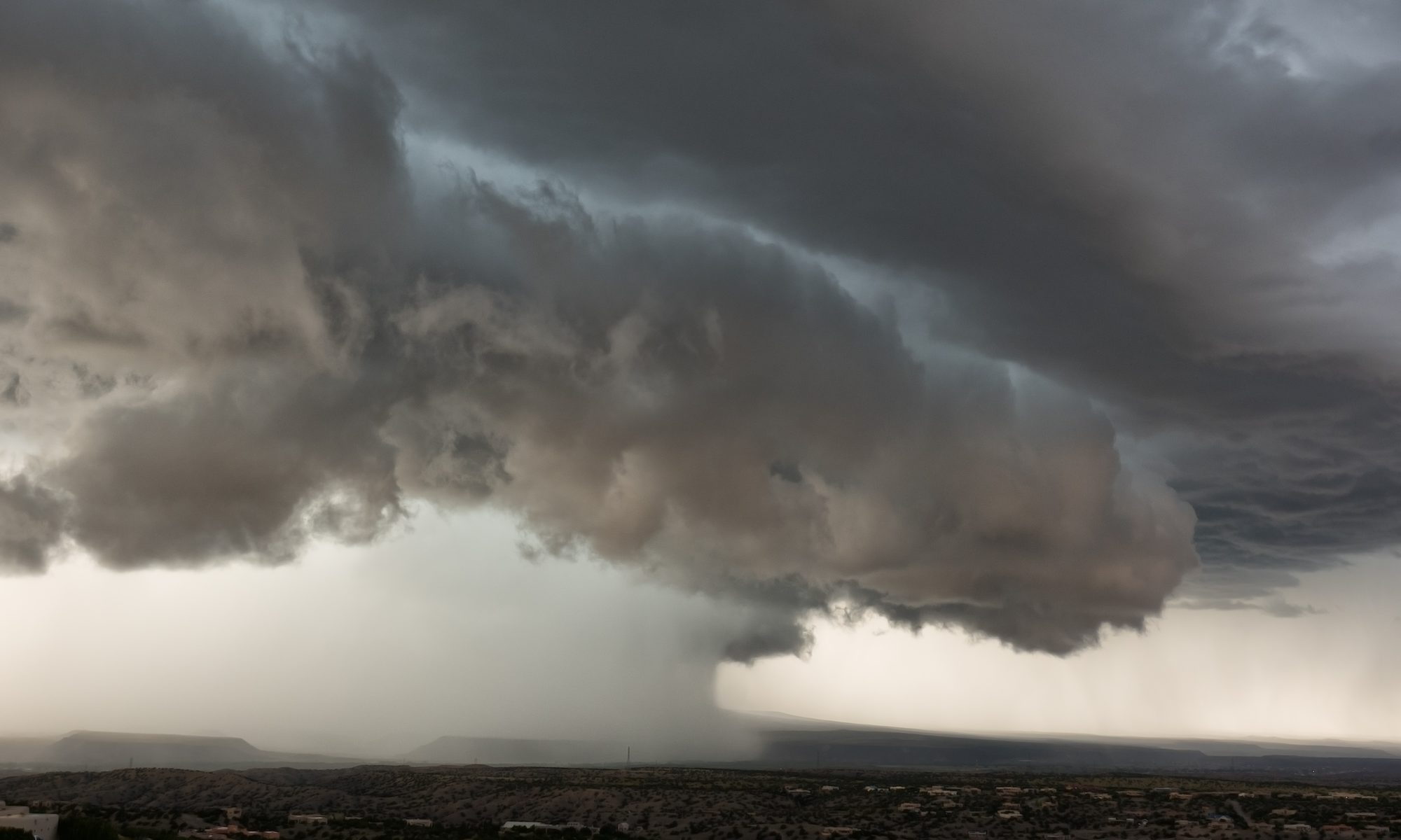
- Fluctuating trend of Rainfall.
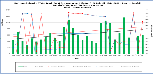
- A drastic fall in rainfall in some particular year results in drying of the surface and soil moisture to the extent that next year’s rainfall is not enough to generate the runoff in the streams. In the year 2002 there was minimal rainfall 314 mm recorded at Jamwa Ramgarh after which Dam never got filled enough to supply water
Man-made Causes
- The dam has been silted up to a depth of approximately 4.57m and resulting in reduction of its storage capacity.
- There are many small rivers and drains in the area which supply water to the Ramgarh dam, but flow of the rivers was obstructed due to huge constructions/encroachments by educational institutions & Sprawling Entertainment Resorts with huge swimming pools
- Rampant Mining and Stone Quarries, uncontrolled rampage and Disappearance of hills, resulting in low stream flow and runoff.
- Increase in activities like Soil Conservation, Agriculture and Watershed Development. Soil conservation department, NGOs and individuals have covered majority of the areas by various activities of soil conservation, which has reduced the velocity of flow resulting in higher infiltration as well as high rate of evaporation.
- There are around 415 water bodies like village ponds, anicuts, contour bundings etc. in the catchment area of Ramgarh dam. The height of these structures is in the range of 2 to 8 m, which is sufficient to retain runoff.
- Water is also obstructed by construction of Ditches and bunding along the contours in foot hills.
- It is also observed that several roads have been constructed by various agencies raised to 1-3 m high embankments in the catchment area and at some places the roads are constructed across the main river obstructing a significant volume of water.
- Several authorized and unauthorized mining activities exist at number of places in the catchment area; such activities have caused obstruction in the natural flow of rain water.
- In most of the catchment areas, farmers have constructed water harvesting structures in the forms of Dols or Mud–bundi (low height earthen dams) in their farms, which harvest water for their local purpose.
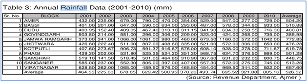
Change in Land use / Land cover
Groundwater Trends & Augmentation
There is increase use of ground water utilization in the areas which is catchment of Ramgarh Dam. This is leading to increase in water draft than the net availability.

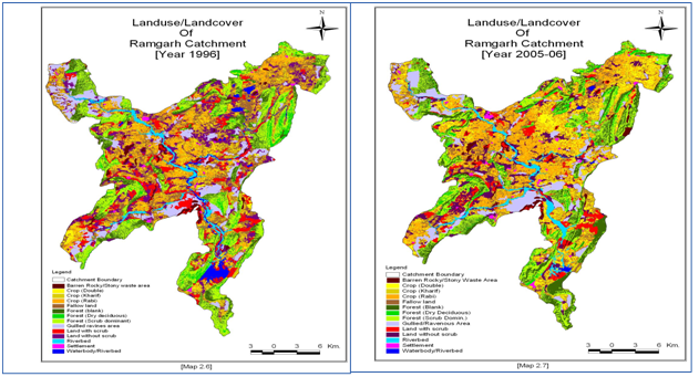
Rainfall Trend – Amber
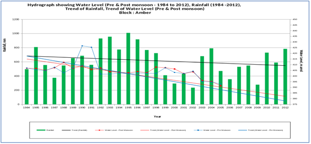
Rainfall Trend – Jamwa Ramgarh
Need for the Scientific Assessment
• The variation can be observed in the two examples of the block Amber and Jamwa Ramgarh
• The rise of rainfall in amber and corresponding fall of ground water level in the block indicating the severity of depletion in the block.
• Similarly the Jamwa Ramgarh is seen with fluctuating trend since it is nearest to dam showing the effect
• Need for Water Balance study in the Catchment Area of Ramgarh Lake
• Use of GIS and Remote Sensing for Impact Analysis.
• Prioritizing the work according to Hydrological Response parameters of sub-basins within Catchment
• There is need for the immediate assessment of the all the catchment contributing to Ramgarh Dam, in terms of Geomorphological characteristic of basin, rainfall and factor affecting the drastic variability. e.g., Increase in agriculture, Industry water, Mining, Encroachments etc., Assessment Basin-wise in order to analyze the severity of Basin Priority treatments for revival of the Ramgarh dam.
Restoration – possible efforts
• As a first step, the removal of all vegetation and SEDIMENTATION within the area of the Lake to achieve the original depth of the Ramgarh lake. This effort will make the basic lake take its original form and this is likely to help filling the lake both by the direct rain fall as well as by the under the ground surface streams. (See PART I)
• Thereafter, Clearing all the encroachment and illegal construction obstructing the flow of stream. All activities in the catchment area of the lake being done by different agencies/departments/individuals must be immediately stopped or strictly monitored.
• Banning mining activity completely, and all the hills should be brought under green zone and steps should be taken for ecological restoration of mining area which is already destroyed.
• The concerned departments must be asked to modify their structures and to remove obstructions from local nallah, drain etc. which are responsible for impending flow into main river course.
• Water bodies having high structures can be gated and water bodies of low height can be modified by constructing spillway/overflow structures in such a way that the water column retained in any water-body may be restricted to 0.75 m only which will serve the purpose of local needs and surplus water will be allowed into main reservoir.
• Modern agriculture management techniques have to be adopted and optimum utilization of the water resource and banning all higher water requirement crops